GIS Software in Out of Home Advertising
The Gewista GIS
Austria’s leading out of home provider relies on a custom WebGIS for media planning. “The tool is indispensable for us,” says Gewista GIS expert Andreas Haider. “We are not only faster but also better.”
Case Study Overview
Customer: Gewista Werbegesellschaft mbH
Application: Media planning in outdoor advertising
Products: Custom WebGIS, geocoding tool
Goal: More efficient and faster processes, improved customer service
User: Sales team (around 80 users), end customers
Gewista - Full-Service Provider for Outdoor Advertising
Clients who book their out of home campaign with Gewista are spoiled for choice with 16,000 classic billboard locations, 1,500 advertising columns, almost 12,000 backlit City Lights and 680 rotating rolling boards. There are also thousands of advertising spaces in public transport and subway stations as well as innovative advertising media in the digital media sector.
The company not only rents advertising media but is a full-service provider for outdoor advertising that can plan and implement regional, national and even international campaigns. This includes analysis, planning, design and production. With in-house market research and geomarketing support, the locations can be chosen such that they actually reach the target group.
It takes effective processes and modern IT to achieve the performance necessary to maintain and expand the leading position in the market. A clear and detailed visualization of the booking process is essential to sell the product efficiently. Comprehensibility and easy handling are key factors.
All of this is best done with a good geomarketing tool. Since the requirements in outdoor advertising are very specific, the client decided on custom WebGIS. But, one step at a time.
“Gewista GIS” - A Modular Online Tool
A single supermarket store in Graz would like to advertise its weekend discount campaign and book the five closest City Lights in the vicinity of the store. A large fashion chain is planning a 24-sheet billboard campaign throughout Austria and defines the catchment area for each store as everything within 10 minutes by foot or 30 minutes by car or within a radius of 1,000 meters as the crow flies.
Both customers can use "Gewista GIS", the freely accessible GIS tool on the Gewista-Website, to get an idea of their options and for initial planning The most intuitive way is to use digital, interactive maps.
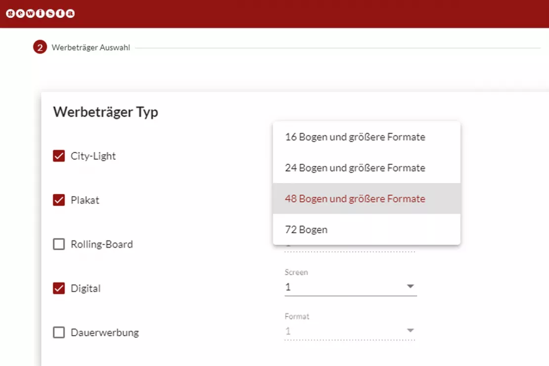
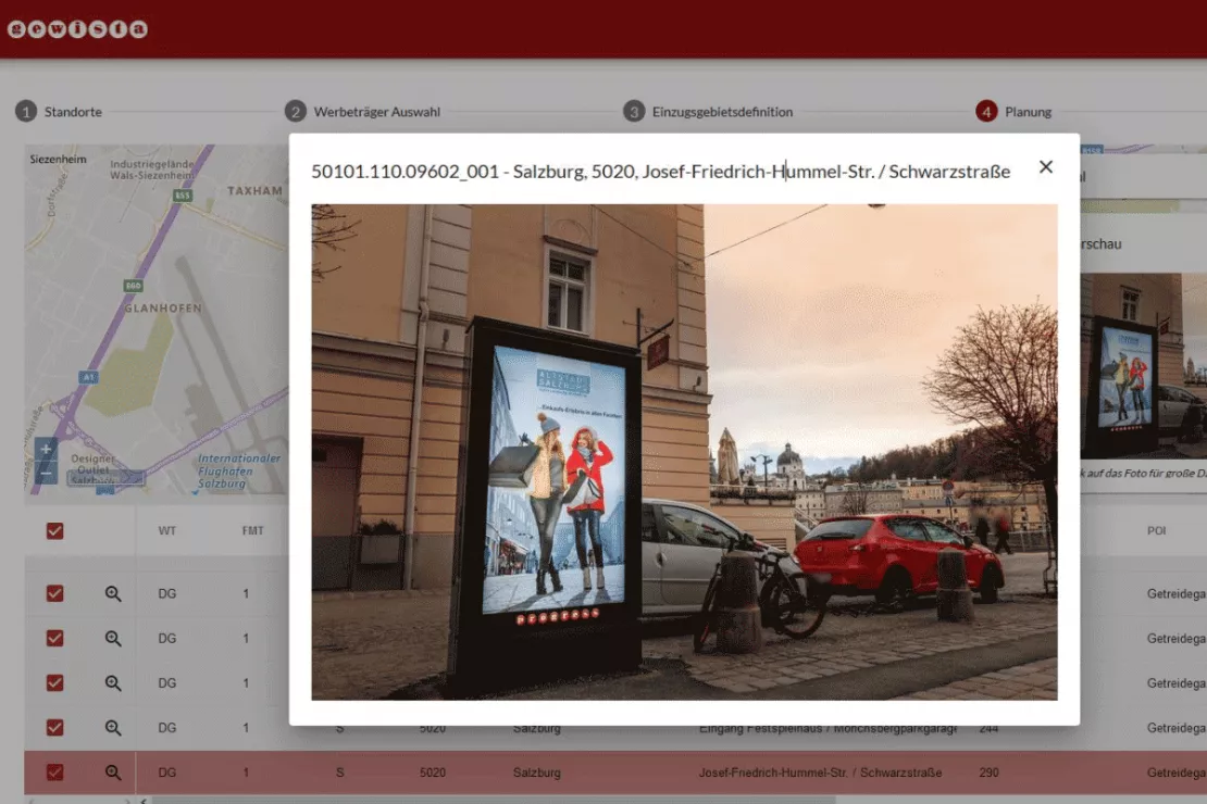
First the locations are entered, around which the advertising is to take place. They can be clicked directly on the map or added as an address with the autocomplete function. After selecting the type of advertising media, e.g. billboards only, billboards and rolling boards etc. (see small picture above), and the criteria for the catchment areas, the tool outputs a rough plan: The possible advertising media are displayed as points on the map. A particularly practical feature is that you can click on these points to display a photo of the advertising media and its surroundings (see small picture below). So the customer is given a really good picture of what they are getting. Finally, the customer can enter the desired booking period and send their inquiry to Gewista.
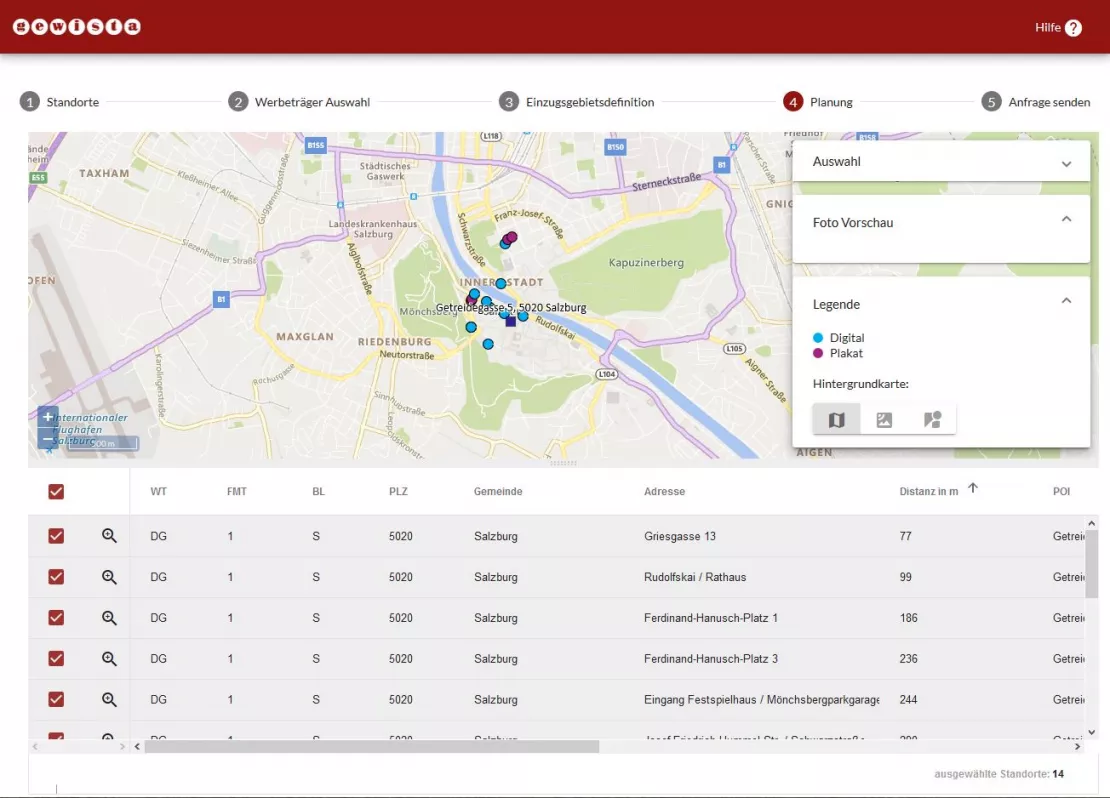
After entering the key data for the campaign, the tool outputs a rough plan. The picture shows a location in the city center of Salzburg (dark blue square) and the proposed advertising media within a 10-minute walk.
Media planning? Out of home? Optimize your processes too! Contact me for more information.
Planning Module as the Heart of the Application
The inquiry is then processed by Gewista’s sales team of 80 representatives. The employees use an internal version of the tool that is equipped with more functions.
“In the internal version we can also upload extensive location lists as Excel files,” explains Andreas Haider, GIS expert and product owner of the tool at Gewista. “Customers often already know exactly where they want their advertising, for example if they have a sales partner network. There is no need to enter the locations individually as we can simply import their list and the tool automatically geocodes the addresses converting them into coordinates, which is essential for spatial representation.”
Alternatively, a Herold database is also connected to the system that already knows the branch networks of the major providers and can load them into the selection with just a few clicks of the mouse. Each point/advertising media location is also listed in a table below the map and can now be individually selected or deselected. This is how the fine tuning takes place.
Once the spatial planning has been completed, the availability over the time period must be checked and the exact timing of the campaign determined. This step takes place in another system, the actual Gewista main software for campaign management. The systems are connected by an interface so that the data can be seamlessly transferred and processed.
“This interface has greatly improved our efficiency,” says Haider, recalling times when the systems did not yet communicate with each other. “We had to enter everything twice and do a lot manually, the process was not stringent. The employees asked for the integration. They got it and are now very happy with it. It saves them a lot of time.”
Campaign Module for Documentation
After the campaign, the customer receives documentation with a listing and photos of the advertising media locations. Haider is also happy about a modern solution here: “We send our customers a link. They can view their campaign online and see the locations clearly on the map and open the photos interactively.”
Here, the interface between the systems runs in the opposite direction. The detailed data for the campaign is primarily in the main software and is now exported back to GIS for spatial representation. “In the past, we used a desktop GIS to create this documentation statically and provided it to the customer in printed form. With WebGIS, we are not only faster, but also better, because we can now offer interactive functions.”
Always Up-to-Date Data, Cloud-Based Service (Saas)
Of course, Gewista is constantly adding new advertising media locations. The data is updated periodically to ensure the display in WebGIS is always up-to-date.
A small additional function ensures maximum accuracy when geocoding new locations: If, for example, a new City Light is not located exactly at the address 101 Main Street, but a few meters down the street at the corner, the point on the map can be moved there with the mouse.
The WebGIS application runs on the WIGeoGIS servers, i.e. in the Cloud. WIGeoGIS takes care of the maintenance. A reliable infrastructure in the Vienna data center ensures secure operation.
“WIGeoGIS has a deep understanding of everything concerning geoinformation. The challenges we face in outdoor advertising are special. WIGeoGIS understands them.”
Ing. Andreas Haider, GIS expert at Gewista
Photo: Preview of the advertising medium in the application
History of a Long Customer Relationship
The last big step, the integration of the two systems, took place in 2018 and, as already mentioned, greatly improved Gewista’s efficiency. However, the cooperation between Gewista and WIGeoGIS goes back much further, namely for more than 20 years. “Back then there were no WebGIS systems, we supported Gewista with their desktop GIS, which they still use for certain tasks today,” remembers Wolf Graf, Managing Director at WIGeoGIS. “Of course, such a long business relationship also reflects the developments in the market. The transition from desktop software to WebGIS and hosting in the Cloud are general developments.”
The switch to the web application took place in 2012 when Gewista launched the first version of the online GIS on its homepage. “We wanted the customer to be able to do the initial planning online, and that can only be done via the browser,” says Haider. “We asked ourselves: How can we modernize this process? Do we use an off-the-shelf WebGIS or do we want a custom WebGIS program? WIGeoGIS was of course at our side to provide advice. Since the requirements in outdoor advertising are quite special, we decided on the second option.”
Satisfied Team
The online tool became such a success that employees also began to work with it. Their requests for more functions and an integration of the systems to avoid double work led to the big relaunch in 2018. “Today’s form is truly indispensable in our everyday lives,” says Haider. “We are not only faster, but also better. Interactive maps simply work best when planning and documenting outdoor advertising.”
Haider consistently receives positive feedback from the sales team. He himself appreciates WIGeoGIS for the helpful advice and support they provide on a variety of other geo and GIS topics. “They simply have a deep understanding of everything concerning geoinformation. The challenges we face in outdoor advertising are after all quite special. WIGeoGIS understands them.”
Andreas Marth, who is technically responsible for the system at WIGeoGIS and Head of the Vienna Service Team, is also satisfied. “With approximately 80 people, we have a large number of users in WebGIS, but few support requests. That is a sign that the system is running smoothly.”
On the Way to Ever Better Processes
Software development never stops. The most recent feature is the information boards, which can be rented permanently as a guide to DIY stores, furniture stores, etc. They can now also be booked through the Gewista GIS.
In the front end, this is just an additional category for advertising media. In the backend, it means a much more complex database. “This greatly improves the efficiency of our processes,” explains Andreas Haider. “Until now, the availability of these boards in our systems was not structured cleanly enough. Now we can see what’s going on at the push of a button.”
Media planning - further case studies and information
CROSSMEDIA - Precisely target your target audience
Media campaign can be optimally planned both spatially and to a given target group.
Expansion planning at dm-drogerie markt
Location decisions are among the most important and long-term tasks in the development of a commercial enterprise.
Custom WebGIS: Request a free initial consultation
- FREE initial consultation
- Non-binding, without further obligations
- By telephone or video call

