Market Analysis, Potential Analysis and Territory Management All With One WebGIS: Example CLAAS
Best Practice: CLAAS, one of the world's leading manufacturers of agricultural technology, makes extensive use of a WebGIS from WIGeoGIS
Case Study Overview
Customer: CLAAS
Application: Market analysis, potential analysis, territory management
Product: WebGIS, integrated geocoder, satellite images
Goal: Decentralized & market-specific analysis & market evaluation for territory managemen
Use: 20 active WebGIS users, 100 users with read & report rights, 600 recipients of PDF reports from over 60 countries
“The WebGIS provides extensive, detailed, product and market-specific information. The complexity of our markets can be clearly and easily analyzed and visualized. With the tool, employees at every level have access to current and relevant data and analyses from anywhere. The WebGIS makes us faster in analysis and decision making.”
Nato Klems, CLAAS
The Customer
CLAAS is one of the world's leading manufacturers of agricultural technology. The company produces and sells combine harvesters, forage harvesters, tractors, forage harvesting machines, telehandlers and presses and offers services and software for this in international markets. The CLAAS Group employs over 11,400 people around the world.
To successfully master this complexity, which results from the product range and markets, for customer and market potential analyses as well as for territory management, CLAAS uses a WebGIS from WIGeoGIS.
Cover Major Analysis Needs Quickly and Easily
The WebGIS was implemented at CLAAS in 2014. According to Nato Klems, the reason for the purchase of the online tool was the steadily increasing need for meaningful analyses. Nato Klems is Manager of Digitalization and Processes for CLAAS Global Sales and has been promoting GIS and geo-analytics in the company for years: “Geoinformatics has played an important role at CLAAS for many years. Originally we only used a desktop GIS to create analyses and reports for management. With this, registration numbers, market shares, market segmentation, customer concentration of our own customers and those of the competition were analyzed and visualized. The various markets started asking for more and more detailed analyses. Ultimately we could no longer keep up with all the inquiries. The idea was born to offer all the markets online analyses and evaluations as a self-service. With WIGeoGIS, we implemented this idea as a comprehensive WebGIS.”
Territory Management with WebGIS
The WebGIS is used at CLAAS for several questions and areas, especially for territory management. According to Nato Klems, there are three important reasons for using the software: “The centralization of the database is the most important reason why CLAAS uses a WebGIS for territory management and planning. In the past, the approval information was stored separately on each desktop and thus scattered throughout the company. The data was not processed and updated regularly. In addition, the data was not available in a uniform format. Essential information, such as approval data, can be entered, maintained, updated and made accessible centrally and uniformly via the WebGIS. The second important point is that we now have a uniform process of territory planning and comparability of market information. And thirdly, the visualization, the easier display of the data and the independence from the central office are very practical.”
With the introduction of the WebGIS in 2014, the process of territory management was redesigned and defined. In the meantime, this has also been integrated as a component in the CRM software in order to map the authorizations and hierarchical structures. This structure is used in all relevant CLAAS applications and systems. “We currently use WebGIS for territory planning in 32 countries. We have become much faster in evaluating our measures, such as approvals. That is a huge advantage,” says Nato Klems.
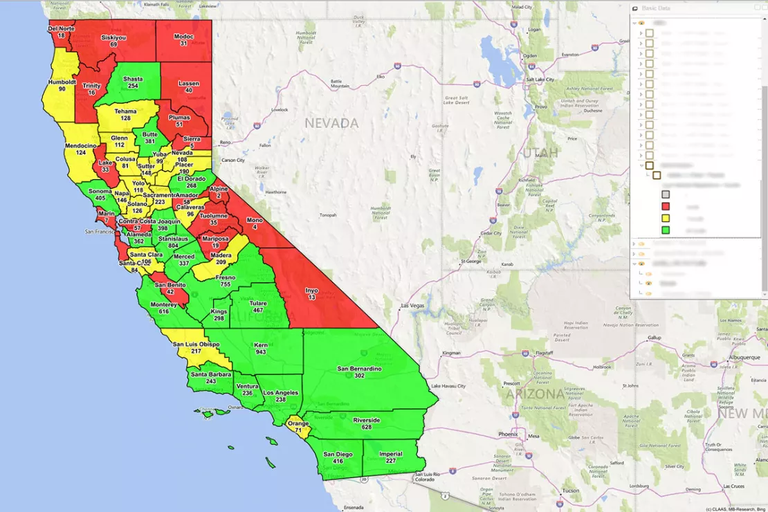
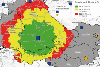
The geo-analysis shows the sales of all self-driving harvesters in California in the past year, broken down by county.
You would like to test a WebGIS? Request your WIGeoWeb test account free of charge and without obligation.
Create Market Analyses in Less Than a Minute
Performance and market analyses are among the most important analyses for any company. These can take up a lot of time and tie up capacities. Nato Klems also knows this from experience: “It used to take a data analyst five to six days from receiving the information to entering, processing and sending all the data necessary for the analysis to the relevant recipients. With WebGIS, creating and sending a market analysis takes less than a minute. This is because there are regular automated data updates and analyses. These are sent to all recipients as reports in a standardized format. The initial effort was worth it.”
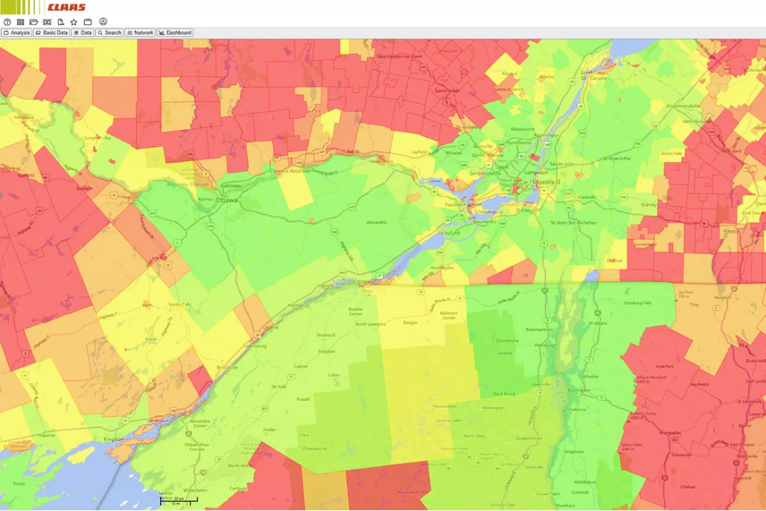
The map shows the division of the various agricultural areas around
Montreal. Different agricultural areas serve as potential indicators for
different products.
Address Validation and Geocoding
As the smallest spatial unit, the address is of enormous importance when it comes to geographic analyses. Companies often struggle with incorrect or incomplete addresses in their databases and systems. In addition, international companies are also faced with addresses that are not structured according to the same logic in every country.
At CLAAS, the JoinAddress geocoder therefore plays a central role in the address validation process. “Every address that comes into a CLAAS CRM system somewhere runs through the geocoder and is geocoded. This not only ensures that every address is complete and correct, but the address points are also blended with our sales structures. This is a huge advantage when administrative structures are changed, for example when two municipalities merge into one. Then we can import the new administrative structures into the system, compare them with the old ones and make a decision as to whether we need to adapt our sales areas due to this administrative change,” explains Klems.
In geocoding, an X/Y coordinate is assigned to a postal address. This never changes in contrast to borders and postal addresses. GIS specialist and senior consultant at WIGeoGIS, Thorsten Lange, explains: “With geocoded addresses, i.e. coordinates, you make yourself independent of regional and communal reforms, which often involve a change of address. This is highly relevant as most countries in the world undertake territorial or municipal reform at least once a year. An impressive example is the comprehensive territorial reform that was carried out across France from 2016 to 2019.”
For France alone, CLAAS geocoded 440,000 addresses with JoinAddress in order to be independent of territorial reforms, changes in administrative borders and postal addresses. Address coordinates also facilitate the quick and easy implementation of in-company territorial reforms. “Experience has shown that companies make territorial adjustments at least once a year because administrative boundaries or ZIP Code areas are changed. But there are also changes during the year when retailers and locations are added or removed. Adjustments are also necessary because potentials and the competitive situation change continuously and companies have to react to this with intelligent territorial adjustments. Instead of spending days updating and adjusting the data, this can be done automatically or with a simple click of the mouse in a WebGIS with an integrated geocoder,” explains Lange.
Benefits of Automating Geoanalysis
In the meantime, CLAAS has set up a large GeoDataWarehouse and one of the largest WebGIS systems in the agricultural engineering sector. The GeoDataWarehouse works according to an automated process: International address databases and area data are automatically updated annually. These are compared with the old, existing ones. Recommendations for action are sent to dealers on the basis of the update and standard analyses.
This automation has many benefits:
- Time saving
- Updates are independent of absences, vacations and local holidays
- Errors are minimized
- Standardized data and data formats
- Better comparability
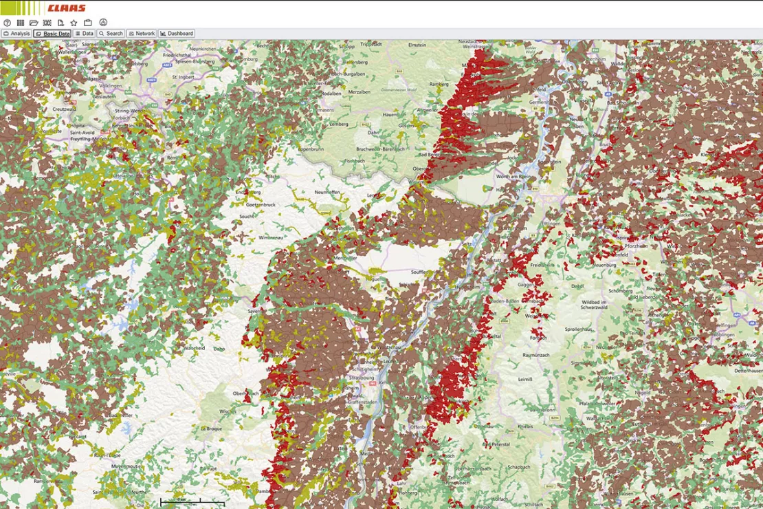
The map shows the division of the various agricultural areas around
Strasbourg and Stuttgart. Brown stands for arable land, green for
pastures and meadows, red for viticulture and orchards and yellow for
differently used agricultural areas. The maps are generated from
satellite images. The different agricultural areas serve as potential
indicators for different products.
Professional and Successful Collaboration on GIS Projects over Many Years
CLAAS has relied on products and services from WIGeoGIS for many years. With good reason. Nato Klems talks about the cooperation: “WIGeoGIS has very professional geo and GIS experts. They know the answer for every geoanalytical question and important development and are always ready and willing to help. We have a personal contact who takes care of all our needs. It is a family company without large consultancy structures. I like the 'let's tackle it' mentality. In all the time working with WIGeoGIS, I have never had the feeling that they just wanted to sell me something. It is always about how we can work together to implement something useful. We really appreciate that. It is also why we offer our biggest compliments to the young, dynamic team and to the system that they developed for us. It functions perfectly even though it had to be heavily adapted to meet our needs. It is by no means normal that such highly customized solutions should work so well.”
Note about the images: The images were made available by CLAAS or generated in their WebGIS application.
Market analysis - further case studies and information

Unicredit Bank Austria: Geomarketing optimises sales structures
Using WIGeoGIS geomarketing software, UniCredit Bank Austria is optimising its sales structures based on physical branches.
Geomarketing in Competition Law
WIGeoGIS creates geographic market analyses for merger control procedures quickly, efficiently and accurately.

Market Analysis Tool
How to successfully perform 6 different analyses. Anyone who does business, must know their market. WIGeoWeb helps to answer the question of "WHERE?"
WIGeoWeb: WebGIS for Geomarketing
WIGeoWeb is your online GIS for business analysis. Interactive maps. Visualize data. Simple. Intuitive. The WebGIS for your company.
WIGeoWeb: Fill out the form, test it free of charge & without obligation!
- Non-binding, free test for 30 days
- Test ends automatically without cancellation
- An employee will explain the tool in a short webinar*
* Information about the free test access: Standard regions with selected data in Germany or Austria will be made available. In Germany, these regions are districts in Munich and environs, and districts of Vienna and environs in Austria. The products of WIGeoGIS are intended for companies and are not suitable for private use. If you need a one-time market analysis, we will gladly make you a service offer.

