ArcGIS vs. QGIS
Is the Open Source System QGIS an alternative to ArcGIS?
Functionality, user-friendliness, visualization options, data formats, costs: We take a close look at all the most important features.
GIS expert Andreas Marth joins us in an interview to examine the two leading desktop GIS software systems ArcGIS and QGIS. What are the advantages and disadvantages of each system? And which GIS comes out on top?
Andreas Marth has been working with both ArcGIS and QGIS since 2016. He knows both GIS systems like the back of his hand. In the ArcGIS versus QGIS comparison, he methodically reviews each criterion. For him, one system clearly comes out on top in terms of user-friendliness, costs and technology.
QGIS as an ArcGIS alternative? Contact me for more information!
Andreas, what is ArcGIS and what is QGIS? Can you give a short summary of each?
Andreas Marth: ArcGIS is a leading commercial GIS system worldwide, created by Esri. It offers extensive functions for the analysis, visualization and processing of geodata. The software is often used by companies and authorities. Its use is subject to license fees, starting in the four-digit range. QGIS, on the other hand, is a free, open-source GIS system that is flexible and user-friendly. It supports a wide range of data formats and has strong support from the QGIS community. It offers extensive functions for the analysis, visualization and processing of geodata. QGIS is particularly suitable for individual customization and cost-effective GIS solutions.
ArcGIS versus QGIS: Let’s go through the main advantages and disadvantages of both systems. Let’s start with costs as the initial criterion.
Andreas Marth: A decisive advantage of QGIS compared to ArcGIS is the cost. QGIS is free, ArcGIS costs a lot. This makes the open source desktop GIS particularly attractive for companies that want to serve many users. ArcGIS charges an annual license fee for each user. These per-user fees are in the 4-digit range.
When it comes to user-friendliness, which system scores higher, ArcGIS or QGIS?
Andreas Marth: QGIS is optimized to be as user-friendly as possible. You can set it up so that only the functions you need are displayed, which makes it easier for many users to get started. ArcGIS does not offer any comparable scalability.
What about functionality: What can they do and how complex are the two desktop GIS systems?
Andreas Marth: Both systems cover almost the same range of functions. ArcGIS is the world’s leading GIS system with an enormous range of functions, but also a large "battleship". It is complex and requires experienced users. It is easy to feel overwhelmed and get lost among the many possibilities. QGIS offers a similar range of features, but is at the same time much more scalable than ArcGIS. It can be flexibly tailored to the needs of the user, e.g. through a reduced user interface that only shows the relevant functions. This level of customization is not possible with ArcGIS. This makes QGIS more practical and easier to use in everyday analyses.

“As an open source desktop GIS, QGIS is particularly attractive for companies that want to serve many users without increasing license costs. It scores with user-friendliness, visualization options and, above all, the variety of data formats it can process.”
Andreas Marth, Head of Solutions, WIGeoGIS Vienna
Let’s take a closer look at compatibility. When it comes to data formats and databases, what do ArcGIS and QGIS support?
Andreas Marth: QGIS supports a wider range of data formats, from Excel to shape files and even geodatabases, than ArcGIS. So QGIS can read and write more data formats than ArcGIS. This is where QGIS has the edge. Another technical advantage is that QGIS can communicate directly with PostGIS databases, a leader in the GIS sector. ArcGIS has limitations here and does not operate with such databases as efficiently.
What visualization and analysis options does QGIS offer compared to ArcGIS?
Andreas Marth: QGIS offers the same capabilities as ArcGIS, from 2D and 3D representations to charts and automated maps. The range of features is basically identical.
Let’s move on to the security and compliance aspects. How do the two GIS systems compare here?
Andreas Marth: QGIS is installed locally, while with ArcGIS, data is often processed in the cloud. This poses risks because it is not always clear where the data is hosted. With QGIS and the appropriate server solutions, you can ensure that data stays local and complies with EU data protection guidelines.
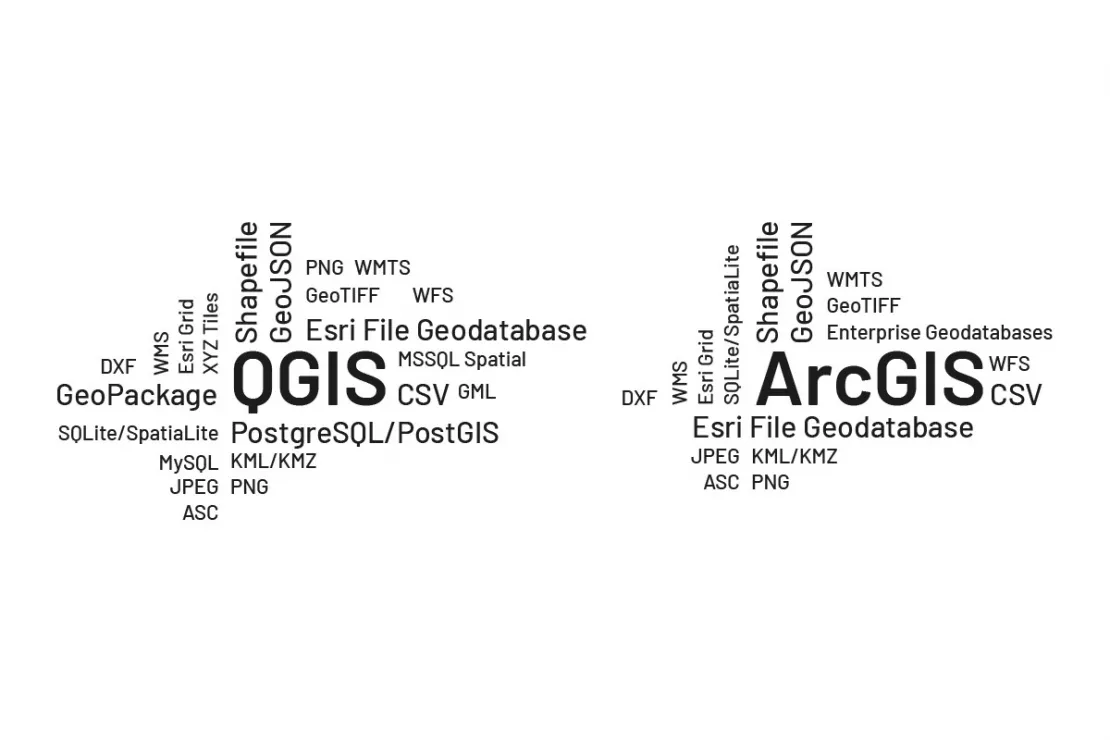
QGIS can read and write more data formats than ArcGIS, including Excel to shape files and even geodatabases. Furthermore, QGIS, unlike ArcGIS, is able to communicate with PostGIS databases, the leaders in the GIS sector.
What about the integration of QGIS data and analysis results in WebGIS applications?
Andreas Marth: QGIS can be combined particularly well with various WebGIS applications due to its open architecture. There are many interfaces to other systems. ArcGIS offers closer integration, but primarily within ESRI’s own product ecosystem.
Can open source software offer the same planning security and continuous development as a commercial product?
Andreas Marth: The QGIS community is active worldwide and contributes significantly to development through plugins and updates. There are regular releases, which is remarkable for an open source project. This also ensures long-term planning security. Many features in QGIS come from community contributions and can be integrated into plugins. This is often even free. The community is now so large that QGIS is used millions of times around the world. The likelihood that QGIS will continue to exist and be further developed is therefore very, very high.
Which GIS is easier to learn and what training options are there for ArcGIS and QGIS?
Andreas Marth: Both are expert systems and not immediately intuitive for everyone to use. Therefore, I recommend an initial training course for both ArcGIS and QGIS in order to more quickly familiarize yourself with the system and its key features. Getting started with QGIS is easier because the system, as previously mentioned, is scalable, allowing you to work with a simplified, customized user interface tailored to your specific needs. There are a variety of free tutorials and guides for QGIS that are provided by the community. That said, there are also free tutorials for ArcGIS.
Are you considering switching from ArcGIS to QGIS? Let us help you make the right choice!
Who can get the most out of QGIS?
Andreas Marth: QGIS is perfect for anyone who wants to perform more complex GIS analyses without having to spend a lot of money on software. It is ideal for businesses that need flexibility and customizability.
Is it easy to migrate from ArcGIS to QGIS? Can I simply transfer my data? What options do I have for moving data from ArcGIS to QGIS?
Andreas Marth: Anyone who has worked with ArcGIS can also work with QGIS. The interface, functions, designations and layout are often identical. To make the move quicker and smoother, I recommend attending a geomarketing training from WIGeoGIS. After that, you will be good to go and start working in QGIS. Migrating your data and projects is also incredibly easy. QGIS can read all the common geodata formats that are also used in ArcGIS. The reverse is often not the case. For more complex projects, there are tools that can easily migrate ArcGIS data to QGIS. So, in short, moving from ArcGIS to QGIS is easy, but the other way around, from QGIS to ArcGIS, is difficult.
ArcGIS vs. QGIS – What is your opinion? And is QGIS a good alternative to ArcGIS?
Andreas Marth: In my opinion, QGIS clearly comes out on top, outperforming ArcGIS in many important points such as cost, scalability, user-friendliness and compatibility with a wide variety of data formats and databases.
Andreas, thank you very much for the interesting interview.
Is QGIS a good alternative to ArcGIS? We are happy to answer your questions and give you a tour of the open source GIS.
ArcGIS vs. QGIS
Comparison of the two current leading Desktop GIS Systems
Costs | ArcGIS | QGIS |
|---|---|---|
Costs | Lizenzkosten im 4-stelligem Bereich | kostenlos |
Scalability | Limited by license costs | Very flexible |
Data integration | Limited (e.g. no PostGIS) | Broad support (also PostGIS) |
Data formats | Limited | Very broad |
User-friendliness | Complex | Customizable |
Expandability | Limited due to proprietary systems | Wide range of plugins, many of which are free |
Visualization | Extensive | Extensive |
Visualization | Strong in its own ecosystem | Flexible with many systems |
Support | Company-based | Worldwide, active Open Source community |
Do you want to switch from ArcGIS to QGIS? We are happy to help!
QGIS, ArcGIS und GIS - further information
What are the advantages of QGIS software?
QGIS is the basis for geo-analytics on desktop systems. With a wide range of functions, open source software is the right choice for numerous applications.
QGIS Plugin for Geomarketing
The WIGeo QGIS plugin expands the QGIS software with numerous functions that make location analyses, target group analyses and market analyses easier for you.
ArcGIS Pro Extension Geomarketing
Extension for location-based analytics ★ Geocoding ★ TomTom based Routing ★ Reporting ★ Potential Analysis ★ Share your maps ★ Visualize your Data
The Basics of GIS and Geoinformatics
What is a GIS? What is GIS software used for and what do you need to use it? Let us explain the basics.
ArcGIS vs. QGIS: Request a FREE Live Demo!
- FREE Live-Demo* of ArcGIS vs. QGIS
- Non-binding, without further obligations
- Online presentation via video call
Do you want to know more about QGIS as an ArcGIS alternative? I will be glad to support you.
* The products of WIGeoGIS are intended for companies and are not suitable for private use. If you need a one-time market analysis, we will gladly make you a service offer.

