QGIS Plugin for Geomarketing
We at WIGeoGIS have expanded our QGIS software with numerous functions that make location analyses, target group analyses and market analyses easier for you. We have put our decades of experience into the WIGeo QGIS geomarketing plugin.
QGIS Plugin for Geomarketing
- Product: WIGeo QGIS, geomarketing plugin for QGIS software
- Areas of application: location analysis, market analysis, target group analysis
- Current Release: 2024 for QGIS 3.34.6
- QGIS: free open source software for desktops (current version is part of the plugin delivery)
- Operating system: Windows, Mac, Linux
- User: GIS and geomarketing experts
- Training: is recommended / WIGeoGIS offers individual training online or on-site
- Support: Yes, we offer customer support packages upon request
What makes the QGIS plugin a game changer for your geomarketing?
WIGeoGIS expands the free GIS software QGIS with useful functions. This makes geomarketing analyses much easier. You save time, nerves and money.
Thanks to the numerous functions of the WIGeo QGIS plugin, you can conduct automatic location assessments in QGIS, sort locations according to self-defined criteria, create hotspot analyses, identify the locations with the highest potential and conduct target group analyses and market analyses quickly, easily and data-driven, as well as much more.
We have placed the combined experience of the geomarketing specialists from WIGeoGIS into our plugin for the GIS software QGIS. Below you will find out exactly what functions the WIGeo QGIS plugin offers.
Want to learn more? We would be happy to show you the WIGeo QGIS plugin live!
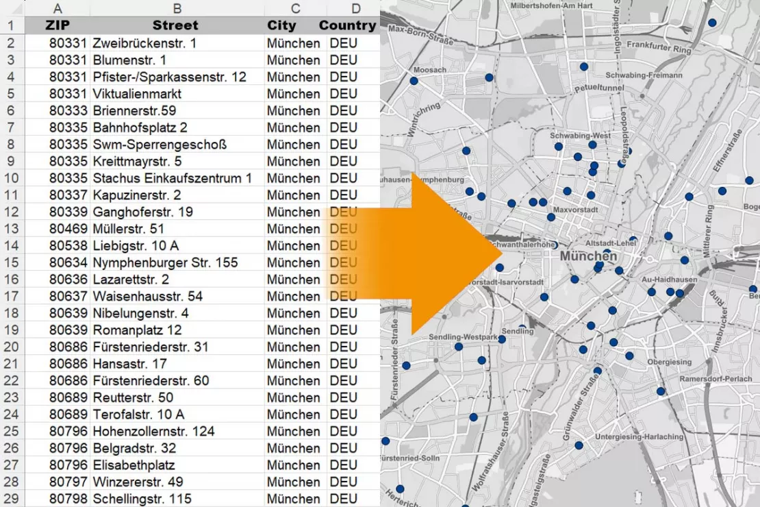
Search addresses, geocode tables, add maps
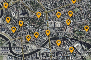
With our WIGeo QGIS plugin, you can display addresses on a map and select different map layouts with just a few clicks:
- Using the address search, you can find addresses and add them as points on the map.
- You can also geocode entire Excel tables. The addresses are shown as points on the map in your QGIS.
- Thanks to the Add Maps function, you can load background maps online into your QGIS project.
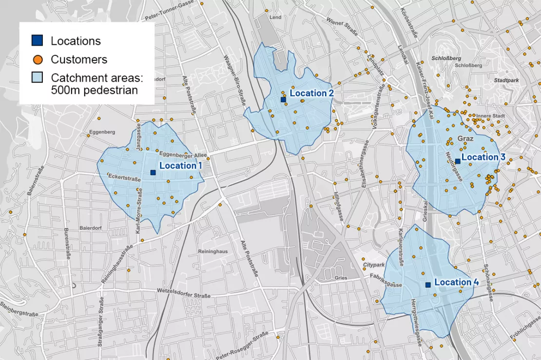
Calculate Catchment Areas and Distance Matrices
With the "Calculate catchment areas" function, you can calculate catchment areas starting from an address or a point on the map. The calculations are based on the road network. You choose the type of transport. As a result, you will receive catchment areas by distance (distance in meters) or time (travel time in minutes). The function can calculate one or more catchment areas for each point.
The "Calculate distance matrix" function calculates either the shortest or the fastest distances between two points on the map. As a result, a line layer is created which contains the path and time information for each relationship between the respective points. The determined values are saved in a table.
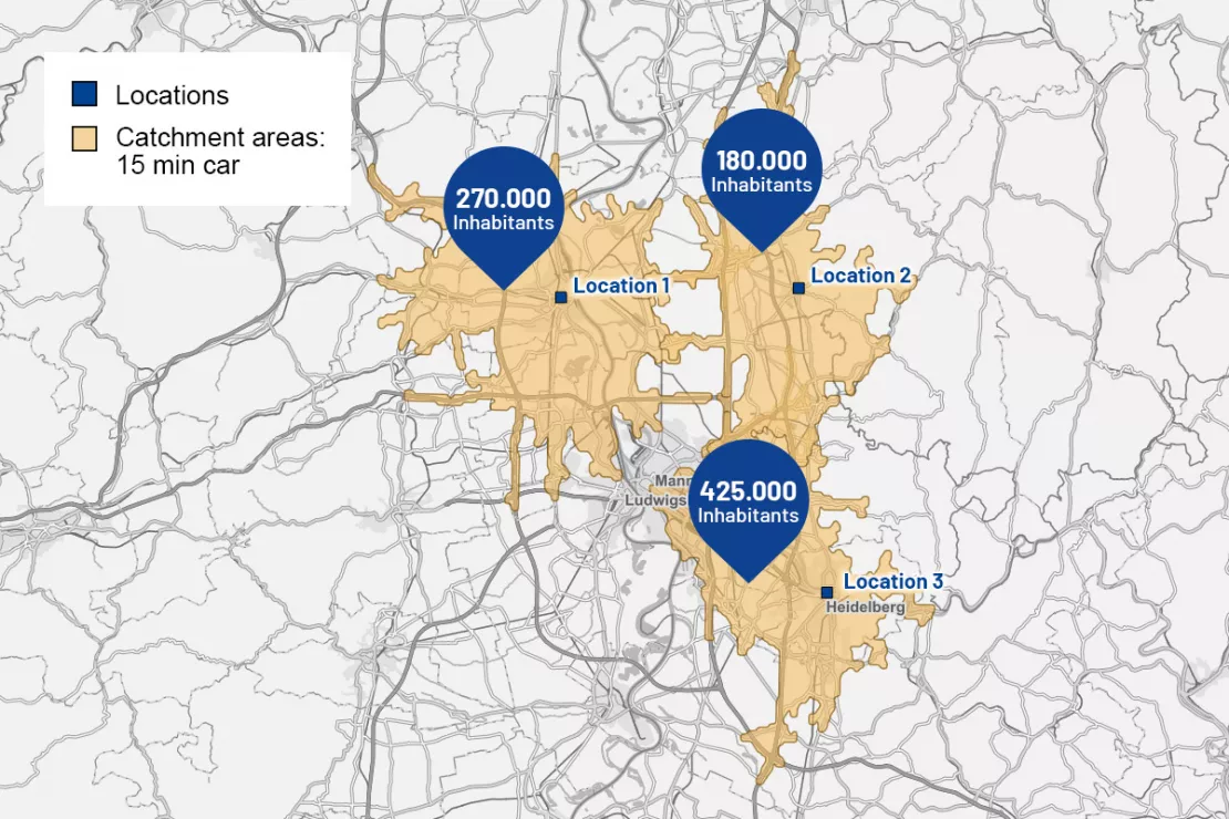
Market Potential Analysis: Calculate, Total and Average Your Potentials
The function group "Calculate potential areas" answers the following questions:
- How many inhabitants live in a catchment area of 15 minutes' travel time?
- What is the average purchasing power?
- How big does my catchment area need to be to cover 10,000 customers or 25,000 residents?
- How big does my area have to be to reach 60 percent of my customers at the location or 80 percent of my potential?
We would be happy to show you WIGeo QGIS, the geomarketing plugin for QGIS, and to provide you consultation! Free with no obligation!

Prepare a Scoring Analysis
Scoring analysis is a proven method for identifying regional potential. Score values for customers, locations and areas are calculated based on current customer, location (sales, area) or potential data (purchasing power, residents).
The scoring function in the WIGeo QGIS plugin creates comprehensive scoring analyses with your data. Table values are automatically classified and scored. You define the number of classes and attributes to be evaluated. The total score is calculated from the sum of the score values.
Tutorials for the WIGeo QGIS Plugin
In the tutorials, we use sample analyses to show you how quickly and easily you can work with our plugins in QGIS. Using ZIP Code areas and target group data as an example, our tutorial shows you, how to quickly and easily find areas with high potential using WIGeo QGIS.
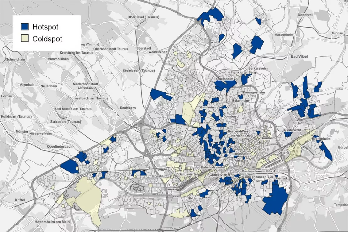
Hotspot Analysis
The hotspot analysis identifies locations with particularly high potential for your business. Different parameters are taken into consideration and weighted differently depending on their relevance. An example: The aim is to identify all those areas in which the percentage of 25 to 44 year-olds is very high (e.g. weighting: 40%), the purchasing power is very high (e.g. weighting: 30%) and the number of competitors is very low (e.g. weighting: 30%).
The calculated hotspot value makes it possible to identify locations that meet all the weighted criteria (hotspots) or those that do not meet any weighted criteria (coldspots). The Hotspot Analysis function also allows you to compare different data sets with each other.
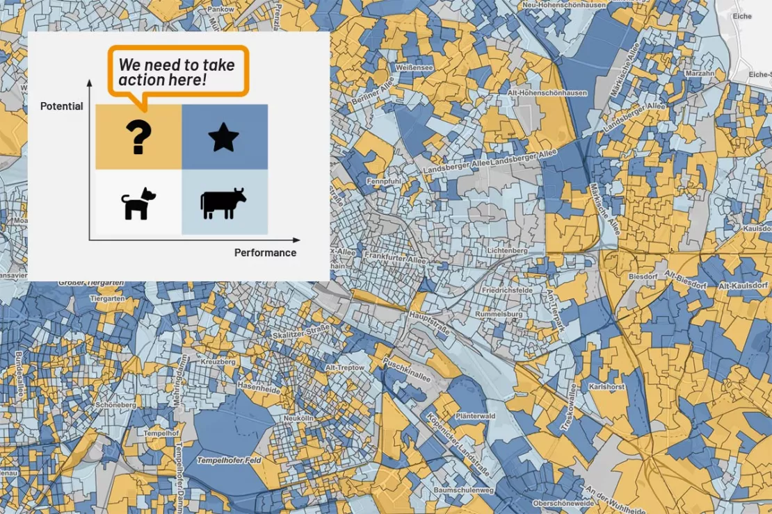
Matrix Analysis
The matrix analysis allows you to compare the performance and potential of your locations.
A matrix shows at a glance which locations are "Poor Dogs" (low potential and low performance), "Cash Cows" (low potential and high performance), "Questionmarks" (high potential and low performance) and "Stars" (high potential and high performance).
The locations are assigned to four or optionally nine matrix fields. The results are shown in color on a map. You can immediately identify the most promising locations.
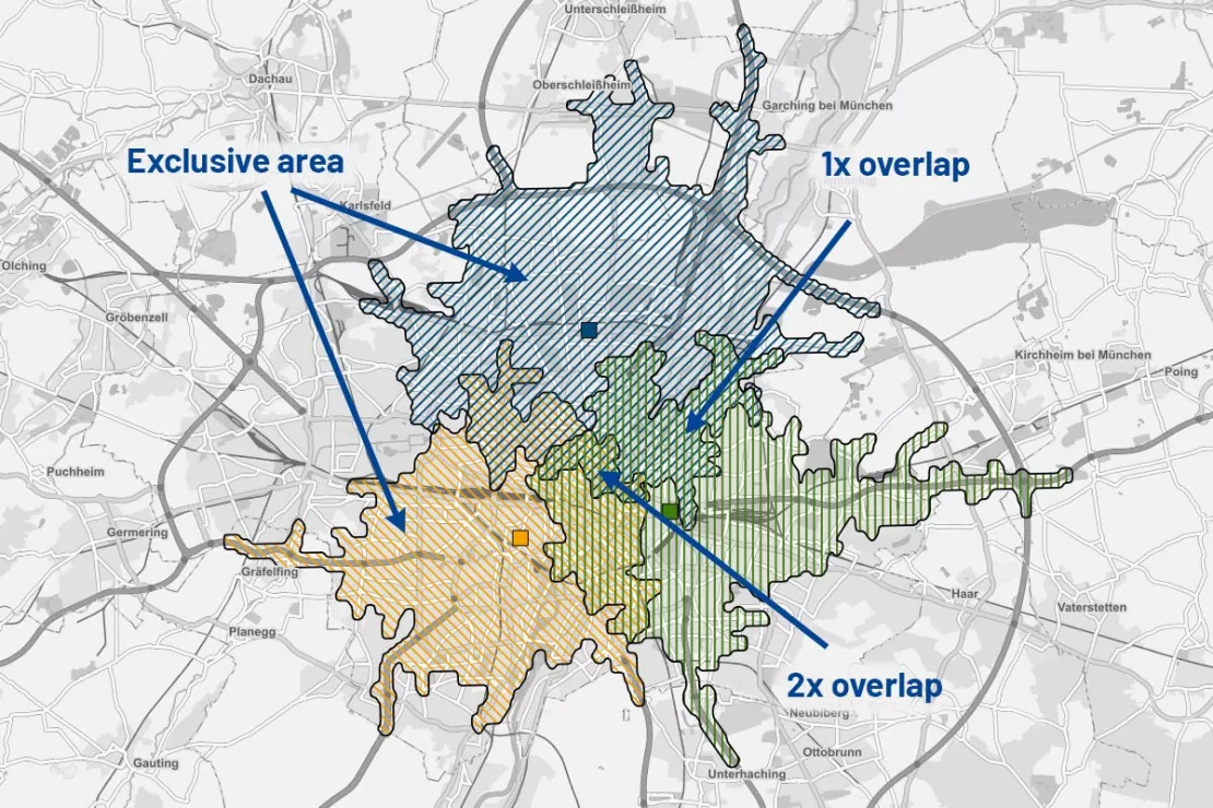
Overlay Analysis: Identify Cannibalization
If the catchment areas of locations overlap, this can lead to cannibalization. This function of the QGIS plugin can calculate:
- Share of exclusive catchment areas (without overlay) and their potential
- Share of non-exclusive catchment areas (without overlay) and their potential
- Area of catchment areas with multiple overlay and their potential
At the touch of a button, you can find out how much customer potential locations are taking away from each other now or in the future.
WIGeo QGIS Plugin: Live demo free with no obligation
Who can benefit from the WIGeo QGIS plugin, and how can they use it?
Find out where your target groups are located with the QGIS plugin from WIGeoGIS! The WIGeo QGIS plugin is suitable for location analysis, market analysis, sales planning and retail network planning. You can integrate demographic data as well as your internal company data. The results are presented clearly on a digital map and additionally in tables or other formats (e.g. in a BCG matrix). This will make location decisions much easier and more accurate in the future.
WIGeo QGIS, the geomarketing plugin for the QGIS software, is suitable for all GIS experts, or those who want to become experts, whether in marketing, sales, administration or other business areas. Our WIGeo QGIS plugin makes many tasks easier for you and offers professional and data-driven results.
Your One-Stop Solution
In addition to our WIGeo QGIS plugin, we provide you with the current version of QGIS and a manual for the WIGeoGIS QGIS plugin free of charge.
You can also book professional training for the WIGeo QGIS plugin with our experienced WIGeoGIS team. We are also happy to assist you with any questions regarding the application and range of geodata and demographic data available.
Learn more about QGIS and other QGIS Plugins
Simply Intelligent Territory Planning Software - WIGeoATP
Automatically plan, divide and visually display sales territories. At a Zip Code or municipality level. In every European country.
Geocode Plugin for QGIS - Simple, Fast, Flexible
Geocoding in QGIS with our plugin! Process, check and correct worldwide addresses. Request our geocode plugin, select the number of geocoding credits you want and get started.

QGIS for Businesses? An Interview with GIS Expert Josef Mayer
QGIS is an open source GIS software that also provides maximum value to businesses for geomarketing analytics. QGIS expert Josef Mayer explains why in an interview.
WIGeo QGIS Plugin: Request a FREE Live Demo!
- FREE Live-Demo* of WIGeo QGIS Plugin
- Non-binding, without further obligations
- Online presentation via video call
Do you want to know more about WIGeo QGIS Plugin? I will be glad to support you.
* The products of WIGeoGIS are intended for companies and are not suitable for private use. If you need a one-time market analysis, we will gladly make you a service offer.
FAQ
-
What makes QGIS an expert software?
You can use all the features and tools provided by the international QGIS community. The extensive expertise of thousands of users and developers have contributed to the open-source QGIS project. This means that you have software from professionals for professionals in different industries at your disposal.
-
Can the functions of the plugins be controlled directly and can the automatic processes be integrated?
The QGIS plugins of WIGeoGIS can be used to automate processes in QGIS. This can work in two different ways:
- Using the functions in the QGIS model builder
- The functions can be used directly via Python.
-
Which geodata format do you recommend for use in QGIS?
The strength of QGIS is that it can read and write many different geodata formats. However, you will achieve the best performance for your analyses by using the Geopackage format.
-
Do I need software training to use QGIS?
Yes, we recommend it. QGIS is a GIS software for experts and requires knowledge of data handling, spatial methodology and working with geographic data. You bring the technical knowledge for your specific use cases, such as location analysis, sales controlling, or market analysis, and we will provide the training.
-
Why do I have to pay for open source software?
You don't have to! QGIS is free! However, services, support, QGIS plugins from WIGeoGIS and individual data licenses are subject to fees.
-
What happens if I don't renew the annual subscription for the QGIS Plugins from WIGeoGIS?
You can of course continue to use QGIS, but not the plugins. A license is required if you want to continue using our plugins.
-
What data is included in the QGIS plugin from WIGeoGIS?
Digital maps, routing networks and geocoding are available via the annual subscription. Demographic data is not included. You can add datasets from a wide variety of sources. This also applies to your own data.

